Bali Hai

The cotton wool clouds, the fine grains of black volcanic sands, the clean sea waters - one can just lie on the beach and while the time away with a tan beneath the balmy tropical sun...

The Volcanic Islets Of Onuma

Ōnuma Park is known for its picturesque, island dotted lakes and majestic dormant volcano, Mount Komagatake. Surrounded by birch and maple forests, a total of 128 small islands can be found in its lakes...

A Journey Over Mountains & Waters

A land of rocky mountains, snaking rivers, steep slopes, deep valleys, and harsh barren terrain. Yet in some places, lush greenery and crystal-clear azure waters abound...

The Bluest Pacific Seas

In the middle of the Pacific Oceans lies an archipelago of islands formed from the fiercest violent volcanoes and made of the browns and greys of cooled lava rocks. The resulting landscape is breathtaking in its purest greens and blues...

Sounkyo's Silver Streams

Bordered by 100-metre cliffs formed by the erosion of tuff, Sounkyo Gorge is situated at the foot of Mount Daisetsuzan - the "roof of Hokkaido", and stretches for 24 kilometres along the Ishikari River...

The Volcanic Islets Of Onuma

Ōnuma Quasi-National Park (Ōnuma Kokutei Kōen 大沼国定公園), Oshima (渡島) 
Hokkaido, Japan
Summer 2011
  
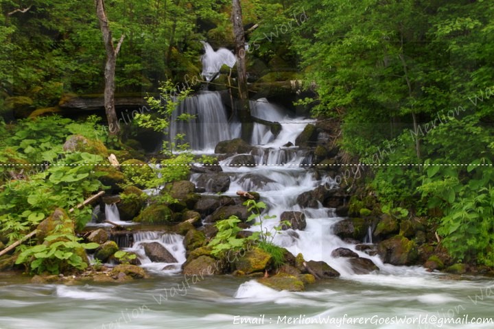
Located only twenty kilometers north of Hakodate, Ōnuma Park (Ōnuma Kōen) is a 90.83 square km (35.07 square miles) volcanic park on the Oshima Peninsula in southwest Hokkaidō, Japan. Designated a quasi-national park in 1958, it is known for its picturesque, island dotted lakes and majestic dormant volcano, Mount Komagatake.
  
   
At 1,131 m, Mount Komagatake's southern base, there are main three lakes - Lake Ōnuma, Lake Konuma and Lake Junsai. These were formed by blocking a river when Mount Komagatake erupted in 1640.

Onuma Quasi-National Park map
Source : travel-around-japan.com

Lake Ōnuma (大沼) with a circumference of 24 km, and Lake Konuma (小沼) at 16 km, are connected by a water channel. A total of 128 small islands can be found in both lakes, forming the park's most attractive scenery.

Surrounded by birch and maple forests, the area around lakes Onuma (large lake) and Konuma (small lake) can be explored entirely on foot via well-defined walking trails through the lakes' peninsulas and islands, several of which are connected with each other by small bridges, in easy 15-60 minute walks.


The full album is available at:
The Volcanic Islets Of Onuma


Sources

        Susukino's Red Lights

        Sapporo (札幌), Ishikari (石狩)
        Hokkaido, Japan
        Summer 2011
        Susukino (すすきの) is a red-light district located in Chūō-ku, Sapporo, Hokkaidō, Japan. It is one of the major red-light districts in Japan along with Kabukichō, Tokyo, and Nakasu, Fukuoka. Currently, the district is congested with many restaurants, bars, hotels, and adult-entertainment establishments. Susukino is not an official designation of any municipality. Rather, it is a commonly used name for a rough area with uncertain borders.

        Susukino is often noted as "薄野" in Kanji, and "ススキノ" in Katakana, and directly translated as "zebra grass field". Various origins for the name Susukino are discussed, but the true origin is not definitely known. One theory is that the area currently known as Susukino was previously covered by Miscanthus Sinensis, literally "zebra grass" ("susuki" in Japanese), a grass native to eastern Asia". Another theory states that the Susukino is named after Tatsuyuki Usui, a supervisor in the construction of the red-light district in Sapporo (Usui is written as "薄井" in Kanji, and the letter "薄" refers to the Susuki in Japanese) .
         
        Bright lights, big city, busy junctions...

        Many eateries serving a variety of tantalizing cuisine...
        (Crab is a specialty here!)

        Floor directories for adult entertainment services...
        (The directory for these services are different from the dining outlets -
        They are more plain and usually do not include brand elements and colours)


        These billboards go up sky high!

        It's interesting to see how the concept of "beauty" is portrayed here to entice customers inwards...

        There are watchers and promoters for the adult services stationed all over town...


        A cigarette vending machine located within easy access to all passers-by...

        Ramen Yokocho is a narrow alley lined with shops
        serving Sapporo's famous ramen in 101 different delicious flavours!
         

        Walking human "billboards" which are just so kawaii!

        Candy floss is sold in several carts in this district. A friendly pushcart owner gives us a toothy smile...

        A bit paradoxical to find a huge religious symbol of the Goddess of Mercy
        within walking distance of this district...

        A police post is nearby too, with its mini-cars patrolling the district...


        The full album is available at:
        Susukino's Red Lights


        Sources

          Goryōkaku's Wartime Past

          Hakodate (函館), Oshima (渡島) 
          Hokkaido, Japan
          Summer 2011
           
          Fort Goryōkaku (Goryōkaku 五稜郭) is a massive, star-shaped, Western-style citadel, which was built in the last years of the Edo Period for the defense of Hakodate against the imperialist threat posed by the Western powers. Built by the Tokugawa shogunate in 1857-1866, it was located in the center of the port of Hakodate, on the island of Hokkaidō. 

          Shaped like a five-pointed star, it allowed for greater numbers of gun emplacements on its walls than a traditional Japanese fortress, and reduced the number of "blind spots" where a cannon could not fire. In designing Goryokaku, Takeda Ayasaburō, a Rangaku scholar, adopted elements of the designs of the French architect Vauban, who developed fortresses responding to the spread of the use of cannon in warfare. 

          Goryōkaku is famous as the site of the last battle of the Boshin War. On December 9 (lunar calendar October 26), 1868, Ōtori Keisuke and Hijikata Toshizo and their troops entered the fort. A week after Hijikata's death, on June 27 (lunar calendar May 18), 1869, Goryokaku fell to the army of the newly-established Meiji government of Japan, and much of it was reduced to ruin. 

          After the fort had lost its military importance, it was eventually turned into a public park in the 1910s. Over one thousand cherry trees were planted along its moats, making it one of Hokkaido's best cherry blossom spots. It has also been declared a Special Historical Site and is home to the Hakodate city museum. 

          "Special National Historic Site (特别史跡五稜郭跡)"...

          A wall divides the friends from the enemies...


          Many visitors have touched the head of the bronze plaque on Takeda Ayasaburō, 
          the designer of the fort, resulting in a golden sheen...


          The elegant Hakodate Magistrates's Office (函館奉行所)...

          The bark of one the many majestic pine trees that line the fort grounds...

          A lot of empty patches demarcating the original buildings...
          Sunset views of the Goryōkaku Tower (五稜郭タワー) from across the moat...


          An out-of-place American flag from a concert in the fort grounds...


          Kids on bikes discussing some games together...


          A seagull which flew further inland...


          School children visiting the fort...

          The history of the fort...

          Cannons located at the lobby of the Goryōkaku Tower near the souvenirs...


          Goryōkaku Tower (五稜郭タワー) with its similar star-like base support...


          The full album is available at:
          Goryōkaku's Wartime Past


          Sources